Bravehearts 2018 – Alapaap Mountain Trail Run

Image may contain: text

Another challenging trail race organized by BTR (Be Trail Ready). A new route traversing Alapaap Mountains in Tanay, Rizal. Race is on February 11, 2018. Registration is still open.!

Be Trail Ready Present ::.. Bravehearts 2018

1st Leg for the Grand Slam of the BTR Trail Running Series 2018.

Distance / Gunstart
7km COT 2:15Hrs / 6:30AM
11km COT 3:30Hrs / 6:00AMRegistration Fee
7km (Php 800.00)
11km (Php 1,000.00)

7km Inclusive
Finisher Medal, Finisher Shirt, Personalized Bib Number, BTR Bandana, Environmental Fee and Tourism Fee

11km Inclusive
Finisher Medal, Finisher Shirt, Personalized Bib Number, Bravehearts Special Edition Trucker Cap, Environmental Fee and Tourism Fee

Registration Period: December 15, 2017 – January 19, 2018Registration:https://manilaboxoffice.com/btr/
LIMITED SLOT ONLY!

Image may contain: sky, outdoor and nature
GETTING THERE:

** Private Transportation
From Cubao take Aurora Blvd. East Bound and continue straight to Marcos Highway. You will pass by Sta. Lucia Grand Mall, Masinag, and Cogeo. After Cogeo, you will traverse zigzag roads.

You will pass by Palo Alto and Garden Cottages. A few meters from Kilometer Post 51, the Welcome Arch to Barangay San Andres is on the other side of the road (left side). This is actually the place that locals refer to as Batangasan or Batangas.

Follow the road leading down to the valley that is Brgy. San Andres. You will pass through two small bridges. Take the left turn after the Brgy. Chapel. The Brgy. Hall cum registration area is located 30 meters from the main road and just before the covered court. From Batangasan, the Brgy. Hall is more or less 4 kms in distance.

Early morning travel from Cubao to Brgy. San Andres is 1 hour 45 minutes.

** Public Transportation
From Cubao, take a jeep or FX to Cogeo Gate 2. Once in Cogeo, proceed to the jeepney terminal adjacent to the market and take the jeepney going to Sampaloc/Tanay. Tell the driver to drop you off at Batangasan/Batangas. (1 hour travel time).

Hire a habal-habal or tricycle to San Andres
Race Updates:
Facebook Event Page: Bravehearts 2018
Facebook Page: BTR – Be Trail Ready

The event takes place RAIN or SHINE!

Trail Chronicles: The Lost Garden of Tanay

In the mountains of Tanay, one place holds a special allure to those who have ran its trails and crossed its rivers…the rugged scenery of Sitio Maysawa. If you have ran any of PIMCO’s Natures Trail Discovery Run (NTDR) trail series in Tanay, you just might have passed some of its rocky terrain, steep uphills and an abundance of streams and rivers that greets you endlessly along its course.

A few days ago, running buddy Jun and i decided to re-visit the trails as we last did during the Pimco Buddy Run2Run 21k held last year. The Maysawa trails are beautiful but jagged, rocky on some parts, wooded on the inner portions  following shallow but crystal clear rivers plus a couple of different ridges through the woods. It throws in a couple of relentless uphills and descents. The terrain on the end part, after reaching Brgy Laiban is a mix of woodlands, creeks, open space and the occasional cultivated field.

We felt like little kids running on a playground again as we  made a recon of the route, starting at the back of the Sierra Madre Hotel and made our way down to Sitio Laiban, another scenic backdrop suffuse with gorgeous trails and rough roads which leads to Maysawa.

This time however, Jun and i went off the beaten path and instead explored the inner sanctum of its wooded area, a path not used on any of Pimco’s trail races before. We managed to run and walk endlessly for about 2 hours and discovered three falls from rushing streams, white rocks and a garden-like deep pond where we had to cling on rocks to get over the other side of the stream.

It was as surreal as it can get, the deep green-colored water was hollow on its surface but you can just see the deepness when you get near its core where the rushing water was like waterfalls pouring into a garden of rocks.

Probably Tanay’s version of the lost Garden of Eden, if ever there was one.

The three falls leading to the site were not too high and the rocks took on a whitish limestone-like texture but were not too large, unlike the ones found at Daraitan, also in Tanay.

We tried to venture further inside this enclave but found it too deep for comfort and found no way out so we headed back to the falls on our way back.

Sharing with you the pictures that we took…

Laiban Trails on the way to Sitio Maysawa

The trails at Laiban traverses along clean rivers

The entrance to the falls and rock gardens

A stranger was kind enough to brief us on what to expect inside. Note the white rocks

A dormant waterwheel near the falls

Jun poses on the small waterfalls

There’s a pond just in front of it where you can take a dip

Venturing past the falls on top

You can wade into the shallow stream or step on those rocks as you wish

The trails lead into wild fauna

The entrance to the eternal place

Jun ventures into the deep green pond

Climbing up past the rock formations. Notice the deep sink hole of the pond on the left

Slippery here. Trail shoes is a must!

It’s either we found the Lost Garden or we were the ones who got lost!

A stair-like rock formation on an imagined Roman garden

A closer look

Endless river trail which seems to go nowhere

We venture back to Sitio Laiban for the 10k uphill run back to base

We will be back here

Anyway, the place is amazing as anyone with a good grip on his trail shoe can climb the rock formations and you’re not afraid to wade on strong streams to wallow in the beauty of this far-off jungle and surrounding landscape.

Definitely a fun discovery trail run and will come back here once again! Bring your cameras with you!

Cold Morning Run At BGC

Last Saturday, me and my training buddies took a break from running our usual route around the Green Meadows, Temple Drive, White Plains area as we drove instead to Bonifacio Global City (BGC) and ventured once again for a 21k run to this now busy commercial hub where races seem almost de rigueur  every Sunday morning.

The rapid expanding skyline has definitely changed the running ambiance of the area where the open spaces and greens are now few and far in between and i kind of miss the fresh air and low traffic that was once the magnet for running in the vicinity. All is not lost though, when you start real early in the morning, when traffic is at it’s lowest and the air is not at its smoggiest.

And last Saturday had the coolest temperature so far around the metro (17.5 degrees) that we had to run a few extra kilometers more before we had ourselves break for sweat. An air-conditioned BGC or we were perhaps transported to the cool city of Baguio–that was the feeling! And it was great!

We zoomed past the area and visited nooks where races don’t usually cover it like Burgos Circle, parts of the American Cemetery, the Emperador Stadium, the inner parts of McKinley Hills and more.

Along Rizal Drive

Betty and Tonette

5th Ave near corner McKinley Road

With the still sleepy Leo

Walk-rest after taking breakfast at Pan De Manila

At one alley

At Burgos Circle

At McKinley Hill

“Thunder” beauties 😛

Emperador Stadium

On our way back from Emperador Stadium.

With Tita Betty

At the Mind Museum

At a playground

Running back for the last 3k of our 21k LSD run

It’s great to be running outside when the weather gets balmy as this. Find time, take your running shoe with you, go out, run and take advantage of the cool air! Offer lasts until 1st week of February only!

Happy running!

Labor Day Antipolo Adventure Run

It’s been a while since i took a long run of more than 21k so yesterday presented the chance to do so. It was Labor Day here, a public holiday so what better way to make use of my free day than by getting those miles in and hang-out with the team! It was going to be a group run, so me and my team mates (Team 90%) would start of at the usual meeting place, McDonalds at Silver City, Tiendesitas.

McDonald's Silver City Mall Julia Vargas Ave.

McDonald’s Silver City Mall Julia Vargas Ave.

A group run for us would always start early and as agreed, i’m dreading the 3:00am start which means getting up at about 1:45am, doing the usual morning routine while waiting for Leo and Sylvia to fetch me by 2:40am on our way to Tiende. We had planned a route all of us will be doing for the first time and that is to scale up the route going to Antipolo church and nail around 25-30kms.

Antipolo Church

So all 7 of us took off and began our run at about 3:15am and were headed out to C-5 towards Eastwood.  All went out on a very fast clip, no slower than 5-6 mins/ km and figured if i was going to sustain this pace up until Antipolo, i was nowhere of getting the mileage as i was sure to bunk out even before reaching our destination.

So i cut loose, did a steady pace of 7:00-7:30 easy and i was so glad i did so. Immediately, i found them way ahead of me and with the still dark C-5 Road, i lost them when i reached Eastwood City.

I was now running alone with just the silent passing of a few cars and trucks as company and with the few dim lights that illuminated the road. I forgot to bring my headlamp nor any reflective material that would warn motorist of this lone runner invading their turf so i was extra careful, confining myself to the sidewalks that were relatively safe.

I felt a sense of liberation running alone as it’s one of those rare times when i get to contemplate, on unfamiliar territory with my mind set to reach Antipolo on my own. I reached Marcos Highway, passing by SM Marikina and one thing great about this stretch is the presence of bike lanes on the eastern side which kept me safe through out this highway.

I stopped by a vendor who was cooking pancakes for P5.00 a piece, got me one and later stopped by a 7-Eleven Store nearby for a Cobra Energy Drink to wash down the pancake. Burp! After a few more kilometers, i reached Masinag then would turn right to Sumulong Highway, the main road towards Antipolo  Church and the dreaded uphills that leads to the church.

The Valley Golf and Country Cub landmark along Sumulong Highway

Surprisingly, the uphills were very manageable, slowly taking it one at a time except when they were long and steep that i had to take walk breaks for about a minute or two. Here, you get to share the road with cyclists making their way to and from Antipolo. Saw some cycling friends including ultramarathoner Romy Doctolero. I finally reached Antipolo Church in about 3:20 (hrs) which is exactly 21kms from Tiendesitas.

Arriving at the jam-packed Antipolo Church

All sweaty but still rarin’ to go!

I tried to look for my teammates who were to visit the  Church but they were nowhere to be found. Learned later that they arrived 20 minutes earlier and were at the back entrance of the church and most of them had changed to drier clothes which was probably the reason i didn’t get to see them. I would also learn that they would not continue their run anymore after the church visit and just drive back to Tiende on Leo’s  SUV who asked his driver to pick them up at the church. They managed the one-way route of 21k.

After taking in a bowl of sotanghon soup with egg and re-filling my Camelbak hydration pack with water, i continued my run and re-traced the route i took, back to Sumulong and Marcos Highways. After a few uphill stretches, it was now all downhill going back to Masinag and before reaching SM Masinag, i saw couple Leo and Sylvia suddenly in their vehicle, stopped beside me and both surprised that i was still running!

The rest of the group had all gone home and since my bags were with the couple and they were on their way home, i decided to end the run, got in the car as they invited me to take breakfast in their home.

I was able to cover a distance of 32.64 kms. in almost 5 hrs, stops included.

This was definitely one of the best runs i had, one great experience of running to Antipolo all by myself and a great way to unwind with running friends. Thanks to Leo and Sylvia for the hearty breakfast and your never-ending hospitality!

Till next adventure run!

Merrell Adventure Run 2013 At Pintong Bucawe, San Mateo, Rizal

Merrell could not have selected a better venue to stage its next trail/adventure run as Pintong Bukawe has been a haven for trail runners and bikers for quite some time now.

Baranggay Pintong Bukawe in San Mateo, Rizal is just about 3.7 kilometers away from the Timberland Heights trails and close to 10kms away from Wawa Dam in Montalban, Rizal. The roads and trails between these places are just georgeous…panoramas of the Sierra Madre mountain ranges, the trails are lush and green, challenging hills and some river crossings.

"Christmas trees" on the sides

Mini pine trees at Pintong Bukawe

Merrell’s next Adventure Race will be held this coming April 27, 2013 and will feature a 5k, 10k and its showcase, the half-marathon distance. Registration has started yesterday so register early as slots are very limited.

Shuttle buses are available for those who want to avail them!

Here are the details of the race:

RACE INFORMATION

Date: April 27, 2013 (Saturday)

Venue: Mt. Sinai, Pintong Bukawe, San Mateo, Rizal

Race Distances: 5km (Men’s & Women’s), 10km (Men’s & Women’s), 21km (Men’s & Women’s)

RACE KITS DISTRIBUTION SCHEDULE

Race kits and singlets can be claimed starting April 1, 2013 to April 21, 2013 ONLY in respective registration areas. Singlet sizes will be subject to availability and will be on a first-come-first-served basis.

ASSEMBLY TIME FOR ALL CATEGORIES:   5:45AM

Distance: Gunstart:

21km 6:00am

10km 6:10am

5km 6:20am

*cut-off time of 5 hours for the whole race will be implemented

RACE KIT INCLUSIONS

•Timing Chip, Race Bib No., Singlet, safety pins

•Rules and regulations

•Directions to venue

•Shuttle option (optional for participants, with extra charge)

REGISTRATION DETAILS

Submit filled-out registration form with your fee from February 15, 2013 to April 7, 2013 at the MERRELL CONCEPT SHOPS listed below.

Here’s a link to the downloadable Registration Form: http://on.fb.me/X94gfF

MARKET MARKET 

G/F Space 23-24 Phase 8, Gaisano Market Market                  

Taguig City 

Tel. no. (02) 836-1560

TRINOMA

Space 2128 M2, Quezon City

 Tel. No. (02) 915-0197        

SM NORTH EDSA-The Annex

Level 3, The Annex, EDSA, North Avenue 

Quezon City

 Tel. no. (02) 352-2737

FESTIVAL MALL

 2/F Festival Mall, Alabang, Muntinlupa City

 Tel. no. (02) 659-3284 

MARQUEE MALL

Nepo Ave. Angeles City, Pampanga 

Tel. no (045) 304-0654

SM PAMPANGA

Ground Floor, Olongapo-Gapan Road

San Fernando, Pampanga

HARBOR POINT

2nd Floor, Rizal Highway 

Olongapo City

 Tel. no.(02) 542-2235

DASMARIÑAS

Upper Ground Floor, Expansion Wing, Governor’s Drive

 Dasmariñas City, Cavite

*Singlet sizes will be subject to availability and will be on a first-come-first-served basis.

WATER AND FIRST AID STATIONS

Hydration stations will be provided at the finish line and along the race route.

This is an eco-friendly event; each participant is required to bring his/her own hydration pack/bottle. Organizers will only provide refilling stations along the race course; there will be no cups to avoid littering.

Medical aid will be available at certain points along the way and at the finish line.

INCLEMENT WEATHER

1. In the event of heavy rain, lightning, haze, fog and other inclement weather or adverse weather condition, the event may be delayed or cancelled.

2. Should bad weather persist beyond 7:00AM or the condition deemed unsuitable, the event will be cancelled.

3. If rain occurs after the race has started, you may continue unless otherwise advised by the designated race official or marshall.

*All Top 3 finishers for each race category for both Male and Female categories each get the cash prize along with a gift bag from our sponsors.

FINISHERS MEDAL All 21km finishers will receive a finisher’s medal. Medals will also be given to the first50 finishers for 5km and 10km categories respectively.

CERTIFICATES will be sent through email within two weeks after the race date to those who finish the course in their specific categories.

SUGGESTED EQUIPMENT

Trail running shoes, hydration pack/bottle belt, cap, running gaiters and energy bar or gel, head lamp especially for the 21K runners.

Views inside Pintong Bukawe:

June is way out front

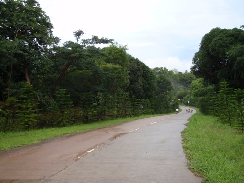
Road towards Timberland Heights

The view on our right

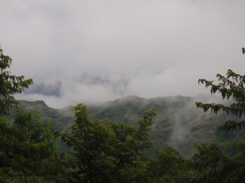
Views from Pintong Bukawe

Entering the trail

Some of the trails inside PB

Wet and windy

Cemented trails inside PB

Going inside the trail

Typical trail inside

RULES & REGULATIONS

General Rules

1. All participants below 18 years old must have their registration forms signed by either a parent or a guardian.

2. Registration is non-transferable and non-refundable.

3. Multiple category registration for one person is prohibited for safety purposes and as this may affect or disrupt race results.

4. Participants who choose not to take part in the event after having registered can decide to withdraw. However, please note that there will not be any registration fee refund. Race slots are also strictly non-transferable.

5. Race bib numbers and electronic timing chips must be worn at all times during the race. Official time will be based on the disposable timing chip provided in the race kit. No chip, no time. Without the timing chip, participants are not entitled to win any of the top prizes.

6. Organizers maintain the right to remove any participants from the race. Injuries and medical emergencies are the utmost priority.

7. No late runners will be allowed to run 15 minutes after the gun start of their respective races.

8. All runners are required to have the proper loop band when they cross the finish line; no loop band means disqualification from the race.

9. A cut off time of 5 hours for the whole race will be implemented. Runners on the course after the cut off time will be pulled out by the Race Marshalls.

10. Time penalties and disqualification may be imposed by the race organizers on runners who do not follow race rules.

11. All protests related to the results must be made in writing and submitted to the Race Director within 30 minutes after the official announcement of winners.

12. The organizers reserve the right to make changes at its discretion without prior notice. The organizers’ decision is final.

PROXY REGISTRATION

In the event that a participant will not be able to personally register and sign the liability waiver form at the designated registration areas; their representatives must bring the following: (1) downloaded form with signature of participant, (2) authorization letter, and (3) valid ID of the participant and representative.

SHUTTLE SERVICE

Place & Time

Market!Market!, BGC 3:00 am

TriNoma, North Edsa 3:30 am

Php300 round trip, first come-first served basis (payment to be settled only at Merrell Concept Shops)

Taking A Look At The Tagaytay To Nasugbu Route

Three long runs in a row and i think i’m getting back into the groove and enjoying what we refer to as the week-end long runs or the long, slow distance (LSD) runs. The craziness started 3 Saturdays ago at the ridiculous route called “Shotgun” where Team 90% and i had to run through hilly villages, scale up a monstrous mountain pass then traverse inside jungle trails then loop back to where we started that took me and my buddies 7 hours to finish covering 38 kms under the heat of the sun!

The following week, we contented ourselves to just running within the confines of Quezon City and completed 32k and again, we were drenched in sweat under searing heat!

Yesterday, our long run took a giant leap further as we ventured into an out of town trip, this time travelling into cooler territory as we arrived in Tagaytay City at about 4:30am. The weather wasn’t as cool as i had expected and the winds from Manila must have rubbed off its heat to Tagaytay although there were some burst of cool winds that blew into our faces during the few miles after our start.

We began our run from People’s Park, a reference point borrowed from the Tagaytay to Nasugbu (T2N) 50k Ultra Race which will be held next month and i’m not really sure if these long runs will eventually lead us to the actual race itself.

We’ll see.

The roads were silent and we witnessed the calm, the picturesque views and the dangers one should expect in running this route. Here goes:

L-R: Betty, Tonet, Leo, Sylvia, Mel, Elaine and me. (Absent: Chito)

Approaching the Tagaytay rotunda

Not too many vehicles that early morning

The one major splendor of running this route is the view of Taal Lake and its volcano at the break of dawn

A small shopping center that should be teeming with customers in a few hours time

It was too early for breakfast and we had to run first

Large housing projects mushrooming in the area

A closer look. Once occupancy starts, expect Tagaytay City's population to rise!

Just a lone biker to witness our run

Pollution-free road for the most part

The Summit Ridge Hotel

One of Tagaytay City's old-time hotels

Approaching Tagaytay's famous radar stations

Another view of Taal Lake

With Tonet taking a break

A farm view on our right

The empty road ahead. However, one has to watch out motorists over-taking cars at your back as they'll zoom past you about less than a meter away!

Approaching Nasugbu, Batangas at about the 9th km

A refreshing welcome

Inside Nasugbu territory

Local townfolks call this housing estate, "Sandara Park".

After completing another 32k run at the T2N route, a well deserved breakfast at Bag of Beans, back in Tagaytay

Team 90%: See you in our next long run!

The Shotgun Route: A Mountain and Trail Run Odyssey

Running 38.3 kilometers in scorching heat seems lunatic specially when it’s about 33 to 34 degrees at its peak out there at the Shotgun Run last Saturday. Crazy as it were, we actually did get to enjoy every minute of it and it seemed to be one enormous victory over the elements of running non-stop hills, undulating mountain roads and technical trails on a route that is known as the “Shotgun Route!”

I only heard about this route through friends on Facebook and they keep raving about its difficulty, the vastness of experiencing a road-hills-mountain and trail run, all pictured into one loop of pure exhilaration that it has become a favorite of many runners.

It was now time to discover it as well. Some members of our running team, Team 90% (don’t ask why it was called such) composed of Mel, Chito, Tonet, Betty, Sylvia, myself and an office mate of Sylvia’s set off in 2 cars and arrived at SSS Village in Marikina and parked the cars in front of an old running friend’s house, Dave Buban. Dave wasn’t running with us that morning and was just content in looking-out after the vehicles while we were out on our run.

I was a bit excited but a little concerned as to whether my plantar issues was going to plague and stop me again on my tracks. The good news is that the bum heel seem to heal very nicely after my disastrous Salomon Trail Run three weeks ago and thereafter, i was able to lodge 15-21k LSD runs with no pain at all.

When we arrived at Dave’s place, some runners were already there ahead of us. Ultra-runners Doc Toto Mina, Jael Wenceslao and Keisha Fule were waiting so we could all start together. We warmed-up with a few minutes of walking and when we were on a flat terrain, we were off running.

Our 5:30am start was rather late as the sun had risen just a few kilometers after we had started. We passed by a few private villages in Marikina, crawled under closed village gates and even got lost from the first group who were leading us by a few hundred meters. From Marikina we entered San Mateo, on its backdoor entrance going through continuous uphills and downhills and flourishes of trees that lined-up on most of the route.

SSS Village borders the hilly town of San Mateo

One of the hilly routes that we had to take

We finally arrived at the road leading to Timberland Heights. The welcome sign to Timberland was familiar to me although i was used to seeing this from the MAIN entrance coming from J.P. Rizal Road where many cyclists seem to be more familiar with. Another kilometer and we made a stop-over at Aling Tinay’s small eatery where our group partook Lugao with boiled eggs and boiled bananas that was to be one crucial nourishment break to survive the dreaded Shotgun Road and trails.

The start of the mountain pass (Shotgun) that climbs up to Timberland

Less than 2 kilometers is the 1st entrance to Timberland Heights, a dizzying uphill of a mountain about 3.5 kilometers long although there is another entrance which is the main one along C-6 Road all the way to Timberland Avenue and is a kilometer away on the north. We took the first entrance.

Just looking at the winding zigzag road going up that mountain, i couldn’t envision myself running those steep inclines. No way! All of us decided to walk those uphills except for Mel (our group’s master show-off) who seems to be reminding us who the King of the Mountain is!:-)

It was at this point when Chito told me that this was the notorious Shotgun Road they were raving about! Damn! A mini Kennon Road of sorts! Here are some pictures i took of the route:

An ordeal of a climb

No shame in walking! Even that mountain biker had to stop and rest.

L-R: Mel, Sylvia, Tita Betty, Ninang Tonet and Chito

This is the "shotgun" route!

We still had to scale up that green peak at the background

Ninang Tonet meets Doc-Romy who was on his way down

The top of the mountain was fascinating! There was a slight cool mountain breeze, breath-taking mountainscape and a picturesque view of Metro Manila. The only draw-back to this route is the constant passing of garbage dump trucks which utilizes this road to dump some of the metro’s garbage into the nearby San Mateo Sanitary dump site. It sometimes pollutes the fresh air that breezes along the canyon ridges.

After a few more climbs, we finally reached the start of the Timberland trails. I’m very familiar with these trails, having ran here several times both during training and trail races although this particular entrance is new to me. At an elevation twice that of Antipolo City, this serene and breezy mountain retreat affords a panoramic view from Laguna de Bay to Mount Arayat in the north.

It was a gorgeous day to run these trails as they were damp, dry and gave my feet and legs a respite from all the pounding we did at the earlier miles. It was starting to get hot and the only concern i had was we were running out of water and the next stop was about 4 kms more when we would emerge out of the trails.

The trails wound up through scenic gorges, lush foliage within a virgin forest although the surface began to be more technical as you enter deep into the woods. Knowing the trails by heart, i was able to skid out ahead of the group and after a few more kilometers, found my way out of the jungle passing by the Timberland Country Club and into the main gate where a small eatery often frequented by cyclists was situated. Took gulps of Gatorade, Cobra Energy drink and lots of water! Whew!

After about 10 minutes, the rest of the group arrived and we all enjoyed the break, taking in some bread, rice cakes and stacked-up more water into our hydration packs before we continued our journey back. We had already ran 24kms up to that point and there was another 14kms to complete the loop.

Here are some pictures of the trails:

The start of the trail to Timberland

Heat was staring to flare up at the start of our trail run

Thankful of the trees that kept us in shade for the most part of the trail run

The view at the opposite side of the trails

Mt. bikers shared the trails with us

Small rocks were all over the place

Mel leads the way

A haven for bikers too

A shaded portion

Keeping our steps at bay to avoid the small rocks

Final group pic before our run back to home base with 15 kms to go.

The trip back was one of the most arduous runs we ever had as we were basically being roasted under the sun. It was just 11:00am but the sun was above our heads so we constantly took walking breaks. At some hilly road, we stopped in front of a front yard and asked the house owner if we could pour ourselves water from a faucet that was situated just outside her doorstep. She might have thought that we were doing some sort of a post-Holy Week “penitencya” so she willingly let us in. We all doused our heads with ladle-full of water. And that was so refreshing!

At about 1:10pm, logging-in a total of 37 kms and temperatures hovering at about 34 degrees, we were now back inside SSS Village in Marikina, all dehydrated and here we were, back where we started but we couldn’t find Dave’s home! I was like a zombie moving aimlessly trying to figure out where the house was and then i realized that i lost sight of the group too! After a few minutes, i saw Betty calling me, waiving from a store and that they had found Dave’s home!

Total distance completed, 38.3 kms and run was finished at 1:30pm. I felt good except for the usual pain in the thighs and butt. And no pain on the plantar…Yebahh! The next day, i amazed myself by doing another 7kms recovery run near UP campus while i was playing the events on my head that transpired during our Shotgun run!

Though the Shotgun route was difficult as it was, i would like to believe that if you would have to do this route, you would also have to cover the relentless rolling hills of San Mateo, Rizal which are still untapped by many runners.

We are slated to do another long run of about 43kms on a new route Dave has discovered and dubbed the “Lost World”. I just hope we’ll be able to find our way back, alive and running!

A bird's eye view of the metropolis

The Rolling Hills of Tanay

One stretch of the zigzag road in Tanay, Rizal

This wasn’t my idea of a “break” I sorely needed. After 14 consecutive days of running (took the whole day off on the 15th), the thought of doing another 3-4 hour LSD yesterday, Sunday, was not going to be a pleasant one. Then along came Tanay, Rizal, a running haven which my group had finally agreed upon after some “vicious” deliberations on where to run this time, tired of the Ortigas-Ultra cycle we had been doing regularly.

The winding highway inside Tanay, its rolling hills, clean air, magnificent mountain vistas and the relative absence of traffic made us want to come back again to explore its charms at a leisurely pace. I was with Betty, Tonet and first-timers to Tanay, Leo, Sylvia, Alex and Elaine. For me, this was just going to be a leisurely, picture-taking pace and for the others, a hill training session (the hills here are treacherous!) but no matter what you call it, it’s going to be a sight-seeing run!

We all met at Masinag, near the entrance to Antipolo at about 4:00am and after buying some provisions of water and food, we headed off to Tanay for the one-hour drive. The early fog was breaking through the roads and we had to slow down until we reached the Sierra Madre Resort, our starting point which by then was still closed to customers. It was pretty cold outside so some of the ladies had to wear light jackets initially and just strip them off at our vehicle support once they were fully warmed-up.

After running for a few hundred meters, I had forgotten to switch on my garmin so I spent the next few minutes fumbling with the dials in pitch darkness to get it to initialize and finding the satellite signal that I had to resort to walking to sort things out. Our target distance, a 30 kms out and back route, starting at the Sierra Madre Resort and turn back after the 15km mark, the same route we did early last year with the Takbo.ph runners.

As always, the fastest among us, Sylvia was raging in front followed by hubby Leo, Elaine, Alex then Betty. Tonet and I were at the tail-end, content with our 7:30 snail pace while taking pictures of the view.

Along the route, I found no less than 4 running groups, most of whom I had the pleasure of running together in different long runs. And like myself, they were coming to grips with the steep hills and getting those mileages up in their own training.

Below are some of the pictures that we took.

Barring any storms or typhoons, this is a great time of year to be running the hills of Tanay. It was cool and overcast (perfect running weather), the roads were dry and the trees and flowers were in full bloom after some rains we had the past few days. I would highly recommend Tanay to anyone looking for a different venue with that rustic, scenic view.

There was just one thing that marred this particular Sunday run and that was the pollution. Not air pollution by any means but the noise polluted by those thundering motor bikes that zigzagged the course and there were hundreds of them! Those powerful BMWs, Ducatis, Harleys, Kawasakis and other smaller bikes were ringing in my ears for several hours. Happens that there was this new motor bike track being inaugurated at the outskirts of the main highway and many groups and clubs of riders were on hand to witness the event.

We ran a total of 30.45 kms in close to 5 hours, including picture stops, eating and walking breaks (there goes my “break”!) It’s a tough but satisfying trot through the mountain ranges, a perfect venue to venture outside of the neighborhood and conquer those steely hills.

Starting on the right foot: A low mountain looms during the early part of the run

Foggy crest right along our course

One trail leading to the inner mountains of the Sierra Madre

That's Tonet running along the road signs

Facing a mountain wall

Tonet poses at the middle. No riders yet this early

About to pass two runners, one wearing a run united shirt

As green as it can get

Large boulders to sit by

One odd view along the highway

It's all downhill from here

A view from the other side, starring Tonet

A small waterfall along the road

Meeting Dyep and Danica along the road

Then there's Aileen and Glo

Team aNR UP-Heartbreakers!

Finally, we see Alex and Sylvia on their way back

Elaine and Leo were not far behind

The lady in (dark) pink?

"Thelma" look-alike? That's Betty who should have played the role of "Thelma's" mom:-)

Meeting Mila and her friend who were doing a 40k run

One of the route's breath-taking view

Riders begin to arrive in droves

A view at the 27th km mark

Finally back at the Sierra Madre Resort with Team CB and Team KTT

Rey, runner at left seems to have ran non-stop all his life

Running in Lucban, Quezon

Old catholic Church in Lucban

In the midst of a forced respite from heavy training due to a nagging Plantaar Fascia injury, i followed a yearning to indulge in a pastime that attracted me to running in the first place–adventure running in the county side.
So i, together with long-time running buddy June with Norman, an old friend, now Washington, D.C.-based and who ran a recent Marine Corps Marathon and their mutual friend, Mico headed out for a strong dose of longganisa smelling, and some easy running in Lucban, Quezon Province.
Lucban, situated near the foot hills of Mt. Banahaw is well-known for its Pahiyas Festival where homes are decorated with fruits, vegetables, other farm produce and kiping. It’s a form of thanksgiving in honor of the patron saint of farmers, San Isidro de Labrador for a bountiful harvest.
However, the celebration is still 4 months away (May 15) and running around town sans the crowd of local and foreign tourists lets you have the place all for yourselves. There’s nothing like getting into a quaint town for an honest measure of easy running and a reality that i still couldn’t run properly with my current injury still at the back of my mind.
After a brief stop-over at a gas station for coffee, the four of us headed to the centuries old San Isidro de Labrador Parish Church for some rounds of running around its vicinity. Our running gear caught the attention of some locals but being an ordinary day, the sparse crowd and the cool weather, people didn’t seem to mind much our intrusion into their daily routine.

Running near the side entrance

Lucban's famous water canals

With June and Norman

Church's markstone

Church's facade

The streets of Lucban are similar to each other–narrow and at times congested with cars, trucks, tricycles, some locals and tourists trying to keep their balance at the edges whenever vehicles try to inch their way in. We had some pleasure observing the mini-canals, where strong current of clear water coming directly from Mt. Banahaw doesn’t fail to put a spell in your consciousness, wishing that we had the same clean canals in Metro Manila.

Adjacent to these narrow streets are small heritage houses with its groundfloors bustling with commercial establishments ranging from restaurants, artifacts, longganisa (local sausages) kiosks and other souvenir shops which include their best selling liquor, the “Lambanog“.

On one of Lucban's narrow streets

Never get tired looking at the canals

Getting inside an old cemetery

Peaceful though a little eerie

Norman's turn

On a paved trail inside a village

Street views: A Longganisa store

Along JP Rizal Street

The National Highway near the Lucban-Tayabas border

It was way past noon when we ended our short running-tour of the town and headed off to nearby Tayabas for a hearty lunch at the Kamayan Sa Palaisdaan Restaurant and Resort. It’s about a 10-minute drive from Lucban and situated just past the border of Lucban and Tayabas. This was going to be the highlight of our stay here.

At the entrance of Kamayan Resort

The restaurant is situated in a massive lagoon where nipa huts are suspended in bamboo stilts, floating like rafts and inside these rafts are benches and bamboo tables where people dine. Specialties are seafoods although different food varieties are also available.

Inside the resort

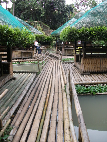
Floating Bamboo rafts

Our nipa hut at right

View from our raft


June at play with some other's...


Lunch included sizzling seafood vegetables

Crispy Catfish

Grilled spare ribs

and a host of others...

Desert is sweetened squash...oh, sooo yummy!

Inside the gardens

At the other floating rafts

Pathways

With Norman

At an arch entrance

There's more of them

Small hotel inside the Palaisdaan

It was already way past 5pm when we drove back to Lucban. Norman bought some longganizas to take home and we were all happy for the experience. Like some charm you can’t resist, Lucban will continue to offer memories of peace and tranquility–a place to lose your thoughts, a place to wander and a place to run.

I suspect we’ll be back again to visit and be engulfed by its charm…some time very soon.

Ciao!

Adventure Run At Ipo Dam

I had originally planned to run another 32k last Sunday to complement the 29k run i did the Sunday before figuring it would be a good way to get back to back LSDs before the big one in Camsur, three weeks from now. However, with regular training partners Betty and Mel “out of commission” (Betty is abroad while Mel is still recovering from his PAU 70k run last Sunday), i called up Harry Contreras, another Runnex member and asked him if i can join his group on their Sunday run. Seems that they were going to do a 19-20k mountain run and their destination…Ipo Dam in Norzagaray, Bulacan. So great, another adventure run!  

Harry fetched my at the Q.C. Hall at about 4:30am and he was with his son, Brian, also a runner. We arrived in Lagro before 5am and met up with his group and turns out to be other Runnex members (Obet and Gani, among them) who were also preparing for the Camsur Marathon. The drive to Norzagaray took another 25 minutes as we finally arrived at a Maynilad Office’s private compound where Obet’s brother works for.  

The Runnex group at the Maynilad compound in Norzagaray

Before long, we were up and about and did some warm up jogs and light stretching as we were warned before hand the the first 2.5 kms were all uphill and the rest of the route would be rolling up and down (whew, another Tanay-like route!). The distance up to the entrance gate was about 8kms and from there up to the Dam itself would be another 2k so it would be 10k, one-way. I was going to approach this run just like an easy training run, walk the ups, run the flats and speed-up the downhills. It would basically be a nice training run, with no expectations of time nor pace–just a fun day of adventure running. 

There were about 14 of us who lined up the narrow but scenic roads with Harry and Gani leading us to the ardous uphill passes that made me breathe heavily while trying to break those hills in segments. To keep the uphills more manageable, i tried to concentrate more in taking the views around me with mountain mists and flora that were attractions to itself. Here are some pictures: 

The run started with a 2.5 kilometer uphill climb

One of the breath-taking views along the way

Lush foliages at the right side of the highway

Continuous uphill going to a place called "Hilltop"

A rice paddy on top of a hill

Foggy mountain crests on the horizons

There were more of this views all throughout the run

Taking a break, from left Edwin, Gani, me and Harry

L-R: Edwin, Gani, Harry and Harry's son, Brian

At the 6th km mark

Coundn't resist taking a picture of this

After 8 kms, we're at the gates of the Ipo Dam at last

Thank God, "Running" isn't included in the no-no list:-)

The Ipo Dam is located at Baranggay San Mateo, here in Norzagaray where it siphons the water from the Angat River direct to La Mesa Dam and ends up at the Balara Filtration Plant in Quezon City. Ninety-five (95%) percent of the water requirements of Metro Manila come from Norzagaray through Ipo Dam. The compound leading to the dam itself have wide streets with tall Ipil-ipil trees lined-up in both sides which zigzags its way down to the bridge area. It somewhat resembles the roads going to Loakan airport in Baguio City except that on this area, the temperatures were now in the mid to high 80s, really hot if not for the trees that shaded us. 

Continuing our run down the tree-lined roads, we saw a small waterfall where we made a stop to freshen up. I had noticed the gushing water below that indicated we were nearing the dam. So close to it, we rushed down to see what’s in store… 

Now inside the reservoir, we re-grouped and took on the downhills slowly. L-R: Harry, Gani, Linda, Rizza, Doc Benny, Doc Lito and Glenda

We had the road all to ourselves

The view atop a zigzag road

Saying "hi!"

Enjoying the downhill but would be a torture later when we climb back those hills

The trees offered shade on a very hot morning

Linda, on extreme left is about to stop and buy a rice cake from that vendor

Just a few hundred meters from the dam

We see a small waterfall up ahead and rush to it

The waterfall can be barely seen, at right

Another shot after cooling ourselves

Winding down the stretch

Getting down to the dam which from here is now visible

Here we are now at the bridge stern of the dam

The view, at last!

The old Ipo Dam

We all were glad to have seen this place for the first time

At the other end of the dam which is all but dried up

A memorial marker which commemorates the recapture of the Dam by the Filipino-American forces from the Japanese invaders

Applying sun-tan lotion and hydrating for our trek back up to where we came from

The painful journey on the way up back those hills. "Gallowalking" rules!

Time seemed to pass quickly and soon we made the exit out. Harry, Gani, Obet and myself decided to run an extra 2.5 kms up the “Hilltop” which was the route going to the entrance of the National Power Corporation where the Angat Dam ( read it here)  is located. Obet, who grew up in the town himself, almost knew all the people we encountered at the streets saying his highs and we joked that if he would run for Mayor here, he would get all the votes, hands down.:-). As we stopped at the hilltop mark, with a birds eye view of Ipo Dam, we met some cyclists who were also on their way to Angat Dam. 

Cheers with C2!

Making our way to the "hilltop", we met these bikers who were on their way there too.

We got on top of the hill near the National Power Corp going to Angat Dam. At the back is the Ipo Dam

Ipo Dam. We were just on that bridge an hour or so ago

Completing about 18k, we headed back the main road on our way back to the Maynilad compound. I took my last sachet of GU banana-strawberry flavored gel and gobbled it down with some 8oz of ice-cold water before the descent. That was a nice long gentle downhill (part of the 1st 2.5k uphill start) that seemed to go on forever. It was an easy 6:30/pace coast until we reached our starting point. We covered a total of 22k. We all had a giant sized breakfast of eggs, giant tilapia fish, spare ribs, corned-beef, egg-plant garnished with tomatoes and onions, rice and even tasted for the first time “baboy damo” (wild pig) cooked as adobo. Yummy! 

Thanks to Obet and family for hosting us a great breakfast and to the Runnex club for taking us in an adventure run. It was a wonderful experience–the scenic route, fresh air and wonderful people–it’s one of the joys of running! 

On our way back to home base, we saw some trails that lead us to this stream

The water streaming here came from the Dam itself, as we were told

When Harry met Obet...Obet, a Bank Manager (in singlet) has about 12 full marathon finishes under his belt